Thursday, May 31, 2012

Memorial Day -part II


In the late afternoon of Memorial Day I spent a couple hours at Asan Beach which is located on the west coast in the central part of the island.  From a historical perspective, Asan Beach was one of the two primary beaches stormed by US troops as we recaptured Guam from the Japanese. This landing beach is 1 of 7 park units commemorating the WWII fighting on Guam.  If you visit ever visit, you can travel from unit to unit and trace the 3-week battle that began on the beaches, spread inland, and swept across the island.  This area is now a Nation Park: War in the Pacific National Historical Park.

This plaque welcomes visitors to this historic site.


 The picture below is a panoramic view take while standing on the beach which aces out to the north.  The short peninsula extending out on the left side is Asan Point.  There is a heptagonal monument commemorating the 50 Anniversary of this battle.  

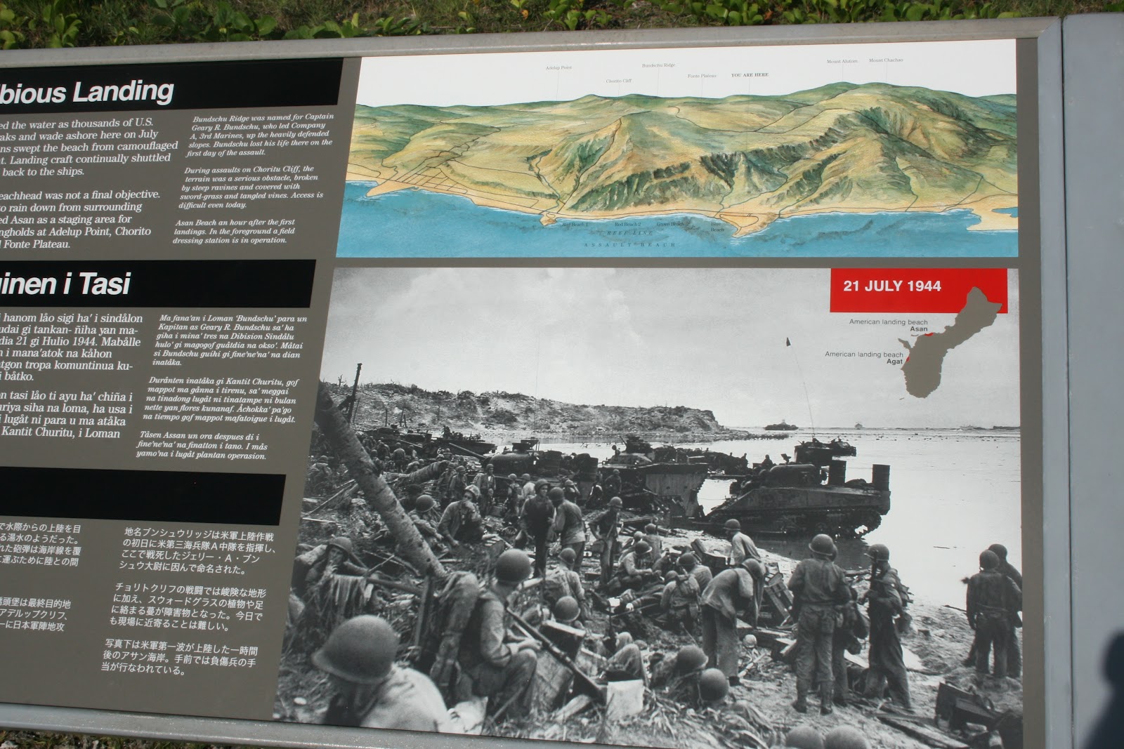
Countless markers are posted around this beach and field describing the events that took place during the War.  One sign recounts the scene: "Mortar shells geysered the water as thousands of US Marines rode amphtraks and wade ashore on July 21, 1944.  Jap forces-concealed in caves, machine-guns nests, pillboxes (to be described later), and artillery bunkers- resisted American assault fiercely.  It took Americans all day to secure this narrow strip of sand.  Though hard-won, the beachhead was not a final objective.  As heavy fire continued to rain down from the surrounding ridges, Americans used Asan as a staging area for assaults on Jap strongholds [scattered throughout the island]".  Below are pictures taken during the Battle.  The first is an American demolition squad blowing up a cave.  The second is a Jap 6-inch gun from the cliff which overlooks the beachhead.


The peninsula on the left in my above picture is the same view seen in the old photo in the signage below.  This old photo was taken 1 hour after the first troops landed.  In the foreground you can see a field dressing station in operation.


Another sign sits closer to that peninsula cautioning scuba divers.  [The Mariana Islands are apparently some of the best diving in the world.  The Mariana Trench,which runs along the east of the chain of islands, is the deepest part of the ocean in the entire world.  The Trench is around 1600 miles long and is almost 7 miles deep.  So divers flock to this region from all over the world.]  After the Battle of Guam, US troops disposed of unexploded ammunition (ordnance) in the sea from the aforementioned peninsula.  50 years after, despite cleanup efforts, live ammo can still be found eroding on Guam, Saipan, and Tinian in hillside caves and on the ocean floor (which I have actually found in the forest-pretty cool!).  

Troops disposing of ammo into the ocean after the Battle. 


This Park exists to honor the bravery and sacrifices of WWII and today a special memorial commemorates those who fought to recapture Guam.  3,033 US and Guam flags were arranged on the main battle field of Asan.  Each US flag represents 1 of the 1,866 US Soldiers, Sailors, Marines, and Coast Guardsmen who were killed or died from woulds suffered during this Battle.  Additionally, 1,167 Guam flags represent the Chamorro people who died during the Japanese occupation and the battle for Guam.

Main battlefield at Asan.  3,033 US and Guam flags represent those who gave their life for this territory.


This is one torpedo presented fo Submarine forces in memory and recognition of the courage and sacrifice of subs whose heroism contribute significantly to the liberation of the Pacific.


Below is a panoramic view of the entire field.  This view is taken at ground level from the park's parking lot.


Maybe I should have presented this info at the beginning, but ohh well.  The fields of Asan Beach have been influenced by several cultures which have contributed to the modern-day Guam.

1892-1900: Spanish government built a leprosy hospital here at Asan Point.  In 1900, a typhoon destroyed that building.
1901-1903: The US government in the Philippines banished Filipino rebels to a prison camp at Asan Point.
1917: When the US declared war on Germany, Americans seized the crew of German auxiliary cruiser Cormoran and imprisoned them here in a tent camp surrounded by barbed wire.
1944: For 2 weeks, in July, US Navy pounded the fields here into a crater morass of mud and sand.  Only a few topless coconut palms survived the bombardment.
1945-1967: Rows of barracks, called "Camp Asan", housed US Navy civilians employees.
1975: The abandoned "Camp Asan" became the reception center for thousands of Vietnamese refuges.
1976: Super Typhoon Pamela destroyed most of the buildings here and the navy subsequently cleared the rubble.
Today: this park stands to remember the fallen.


This last piece of the post tries to gives you a glimpse into the past as soldiers overtook the beachhead.  Put yourself into the boots of our troops; it makes this section especially captivating (and terrifying)!


As you come off the beach and cross the open field pictured and described ealier, this hill/cliff/ridge is the first formation you see.  Keep in mind that Japanese soldiers are buried in this hillside with huge cannons and machine guns.  You should know that this hill sits by itself therefore retreat would not have been an option for the Japs.  Like a cornered animal, the only choice was to 'fight to the death' and they did just that. 

Taken from the left of Asan Ridge

Same Ridge taken from the right side.


Now you have stormed across the field, under constant barrage of Japanese bullets, and make it to the base of this 'hill' (at least it looks like a hill from afar).  At you stand below it, the hill is quite steep and intimidating.


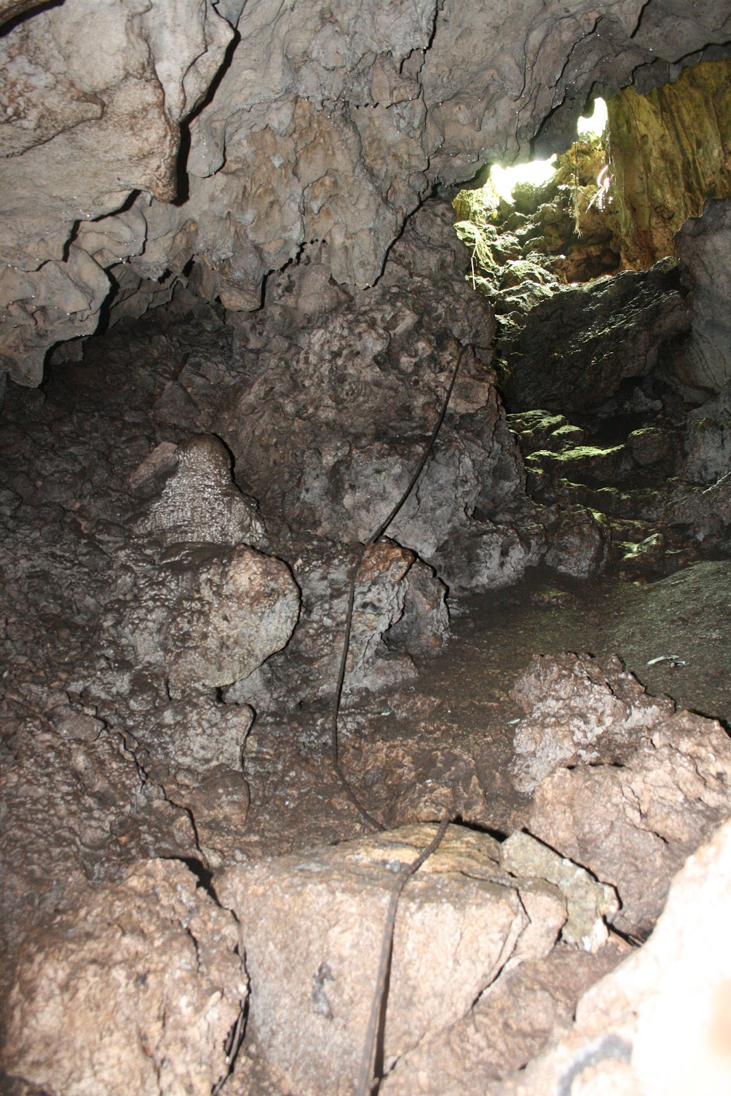
Jap soldiers are holed up in shallow caves, crevasses, and pillboxes fighting for their life.   In preparation for this expected invasion, Japs dug hundreds of caves like this throughout the island using forced labor (mostly Chamorro and Koreans).  Caves and tunnel systems like this honeycomb the hills and ridges throughout Guam.  The reason they did this was b/c they were outnumbered and planes bombarded them from above; so their best protection was to go underground.  After Americans secured the beachhead, the battle became a deadly game of hide and seek.  Below is that same cave as above taken during the battle (top picture), looking into (middle picture) and looking out from the cave (below picture).


I can't imagine being a US soldier ordered to take over this hill and then encounter Japs hiding in a dark cave like this.  If you follow the path (up to the left of the above picture)  which leads to the top of the hill where more Jap soldiers are waiting to kill you or die trying. 

Toward the top of the hill are 2 bunkers barely 4 ft tall with a small window large enough to shoot through.  These bunkers protected the paths leading up the ridge from the invading US.

View of the bunker from the path leading up the ridge.

Inside view of the bunker.  A 4ft tall x 3 ft wide space with a small gun window is all that constitutes this small but effective defense post.
Currently, this bunker is only accessible by belly-crawling.  The opening is a couple feet high.  I assume it was not always this way and the elements have closed the opening.

 
Today little is left now from what was surely a bloody and chaotic scene atop Asan Ridge.  The few bunkers (pictured above), some scattered rusted gun/cannon barrels (below; see if can spot them all in the next 4 pictures), a beachfront defense post (below; fortified for tourists' protection), and overgrown foliage are all that remain.

Some discarded gun barrels and old pipes.
2 broken and discarded gun barrels.
As is common with these old metal parts exposed to 60 years of weather wear, these barrels flake off much like tree bark.
An old gun barrel buried in the earth.


Large bunker facing the opposite bay on the backside of the hill.  This bunker looks out on a different (but in close proximity) bay than Asan.


 Standing atop Asan Ridge, this is the view looking out onto Asan Beach and Asan Field.  I'm sure the view 60 years ago was not as majestic and beautiful as the one I took below.


Asan Beach and Asan Field from the top of Asan Ridge.


All pictures presented in this post are property of the author.  Unauthorized use of these pictures is prohibited unless given explicit permission by the author.


Tuesday, May 29, 2012

I survived a tropical storm!


I kind of lied in the title .  It wasnt a tropical storm but a 'Depression' which apparently has a different meaning to meteorological nerds.  [It says a lot when you're called a nerd by a biologist bird-nerd like myself.  If you didn't know, there is a secret hierarchy of nerds and those who stare up into the sky at clouds are among the nerdiest! JK]  From what I hear a depression is a relatively low grade incident but can still cause some damage.  We got LOTS of rain and winds up to 35 mph.  Being from Oklahoma and having seen my share of tornadoes and storms, all I noticed was a refreshing shower and a nice breeze.  Locals had their windows boarded up and typhoon shutter closed ready for the worst.  I wasn't that worried about it which means I'm either naive and overly confident (and should have been terrified) or I recognize how cautious weathermen can be with their weather advisories.  I dont know; either way I'm alive.  I couldnt go into the field to work and we lost power for a couple hours which meant I got to read and do crosswords.  Other than that, it wasn't that bad.  I get to say that I survived a tropical depression.  I lost a day of field work, but was luckily able to make it up.

I've got some other pretty pictures from a walk along the beach that I'll probably show in a new post in a couple of days.  I need to go into the field so I'll get back to you all.  Sorry I waited 2 weeks between post but things have been busy and hectic

Sunday, May 27, 2012


Memorial Day -part I


First and foremost, I want to thank all those who have served, are serving, and will serve in our armed forces.  Their service affords us so many luxuries that we often take for granted.  Guam, functioning as a major military post in the Pacific, plays host to many such people.


As a result, today is filled with festivities across the island celebrating the men and women who defend our country.  Who knows . . . . I may wander down to the Beach Bar for some live music, drink specials, and a good old-fashioned cookout.  The Beach Bar is located on Gun Beach on the north side of Tumon Bay on Guam's west coast.  Unfortunately there is no signage historical  identifying the significance of this beach but it is definitely a favorite hangout for locals on Sunday (Family BBQ day).  On the north side of this beach is a single anit-aircraft cannon nestled in the rock wall which faces the ocean.  Below are a few pictures of that cannon and the area around it.  As I said before, this is a popular cookout spot so don't mind the trash.  The picture captions give some more detail.


The single visible anti-aircraft cannon on Gun Beach, Guam.  This is standing on the beach looking back into the cliffs with the ocean at my back.
This is a small den directly behind the cannon.  You can imagine a few soldiers who man this cannon hunkered down back here.


If you look to the left of the previous picture, you can see this little nook.  Might be a good place to store ammunition for the cannon.

If you look to the right of the cannon, this crawl way runs parallel to the beach.  In the background you can see the wall which would have protected the soldiers.  In this wall are windows where you can imagine they fired upon any beach invaders.  As I said before this area is a popular BBQ site so dont mind all the trash.'


This is the view from behind the cannon looking out at onto the bay.  This is the view (minus the big tree on the right) defenders had as they tried to protect the beach. 

.

Again, thank you to my family and friends who've answered the call to protect our country and defend those of us who call it home.

 I APPRECIATE YOU!!


All pictures presented in this post are property of the author.  Unauthorized use of these pictures is prohibited unless given explicit permission by the author.


Monday, May 14, 2012

BACK ON GUAM

So I set up my primary experiment on Saipan and now I have returned to Guam to set up the same experiment here.  The objective is to set the experiment up on Saipan and Guam as close together (temporally) as possible.  Since I can only be on one island at a time and dont have a field assistant, this island hopping will have to suffice.  The plan now is to stay on Guam for 3 more weeks (running other secondary experiments) until I go back to Saipan (to run the same secondary experiments as well as clean up the primary experiment).  I know some of you probably dont care what silly science fair experiments I'm running and just want to see more pictures.  I just thought I'd share in case you were wondering about all these inter-island trips.

Like I said, I've been on Guam since the 8th and have been busy setting up experiments.  Unfortunately, I dont have many cool pictures or fun stories to share this time.  :(  So this post will probably be short and help put you insomniacs to sleep.


3 unrelated stories:

En route to one of my sites is a pitch black cave with a large fresh water pool.  People will hike down and swim in this pool by candle light.  The hike to the cave is a little long and the rocks are slippery when wet (my backside can attest) and the cave itself is hard to traverse w/o a flashlight.  But the cave is a cool (figuratively and literally) spectacle and refuge from the mid-day humidity and sun.  I was alone and had never been into the cave so I wasn't sure how far I had to descend to actually get to the pool.  It didnt take long before I found myself shin deep in frigid water.  The water is so glassy, clear, and calm that I had stepped right down into it w/o ever seeing the water surface.  Ohh well, what can you do?  I took my shoes off and had lunch on a rock with my legs dangling in the water.  The far end of the cave was lit by a couple wax candles (so I must have just missed other visitors).  My beautiful wife, surf'n'turf, and a violinist were the only things missing to make this romantic rendezvous complete...maybe some other trip

I had just stopped for lunch between sites and didn't have much time to explore.  Perhaps I'll go back and wander around and deeper into the cave.  Then I'll have more to share.  Here are a couple pictures of the entrance into the cave and the pool

Pagat Cave pool

Looking up at the cave entrance/exit from the fresh water pool


I am REQUIRED to walk along a beautiful, secluded, white-sand beach to access another one of  my sites.  It's a real drag having to look out along the gorgeous coast with the teal/blue ocean to my left and the lush green jungle to my right.  Let me tell you, I could not be more miserable hiking through this picturesque scene.

(I am kidding for those who haven't picked up on my dry sense of humor)

While walking on the beach-forest edge I saw this rusted wheel lying in the shallows with a Blue Sea Star (Linckia laevigata) attached to the tire wall.  Not much of a story here just a pretty picture of one of the Mariana's sea creatures. 


Many of you know that I love to 'people watch'.  Luckily, I married someone who enjoys this activity as much as I do.  The improvisational commentary that ensues when we are together makes it that much more fun and hilarious!  One of our favorite times of year is when the State Fair/Houston Rodeo come to town.  Besides the amazing (and unhealthy) food, the people watching is some of the best in the world!  I feel obligated to also give props to the shoppers at Walmart who come in a close second.

Well, I may have found a new player in this competition for "The best places to watch mankind do stupid stuff/ look completely ridiculous/ generally make me feel better about myself"!  This beach in front of the Hyatt Hotel was a prime location.  It had been a long day and I was sitting in a chair reading and watching the sun set.  The hotel was hosting a BBQ of sorts for the hotel guests (which are predominantly Asian [mostly Japanese] couples on their honeymoon or ENTIRE extended families on vacation).  It was a few minutes before 6:30 and the sun was painting delicate shades of pink and blue on the towering clouds on the sea's horizon.  About this time, I noticed the the band had stopped playing and dinner was paused so that a hoard of tourists could RUN to take a picture of this sunset.  I dont know why I was surprised b/c Asian tourists are incapable of letting a photo op like this pass w/o getting a shot of their significant other sporting a peace sign (using the camera that is always w/in arms reach).  And boy, they come out in full force like Catholics when the Pope drives by.  As these people ran to the waterfront looking out onto the ocean and taking pictures of this Monet-like scene, I'm sitting in my chair having trouble holding my camera steady b/c I'm laughing so hard.  I've turned around towards the beach shooting the army of tourists trying to get their perfect shot.  Unfortunately, as I look through my pictures of these picture-takers, I dont have a good phtot of this ordered chaos.  All I had with me was the camera on my phone so the quality is blurry and hard to see.  So the best I can do is describe it to you.


Wow, that post turned out a little longer than I anticipated.  I'll wrap it up and extend to all the moms out there a Happy Mothers Day!  Thank you for everything you do and love you lots!


All pictures presented in this post are property of the author.  Unauthorized use of these pictures is prohibited unless given explicit permission by the author.


Sunday, May 6, 2012

2012 Escape from Managaha

One of the fun parts about doing research in different parts of the world is involving yourself in the local culture and participating in the community.  Here on Saipan that's fairly easy b/c the local people are great and there are a good number of white folk who are inevitably linked to each other by only a couple degrees of separation.  White people on the island typically fall into 1 of 2 categories: (1) temporary visitors who vacation for a week or two; (2) employed in some capacity by a government or wildlife organization (e.g. Dept of Fish & Wildlife, Dept of Environmental Quality, researchers and other biologists such as myself, etc).  You could make a strong case for a 3rd category comprised of a moderate number of lawyers-but we don't count them b/c lawyers are a different breed all their own...JK Jed!

I digress!  As a part of my efforts to partake in community activities, I joined (more like I got talked into it) the Saipan Swim Club for their 9th Annual "ESCAPE FROM MANAGAHA" (*cue deep voice and foreboding theme music).  It's an event held this past Saturday (5/5) that draw around 40 people ranging in age from 6 to almost 70.  Swimmers are "marooned" on a small islet that lies in the lagoon almost 2.5 km off the west coast of Saipan and we had to cross the ship channel back to Saipan (dont worry, there were kayak and boat escorts so we didn't get run over).  Now, I'm no Olympic swimmer or polo player, but I was a lifeguard for 6 years (which is a tough job people!!  We did NOT just sit around and work on our tans as is the common misconception.  We did other stuff like blow our whistles every once in a while).  This was supposed to be a fun swim, not a race...or so I was told.  So playing the odds, I figured I could do this.  I shouldn't have a problem beating some kids and old farts in a fun swim.  Key word there was 'shouldn't'.  


Managaha is nearly 2.5 km to the NW of Saipan.  The pins indicate the start and finish.

Showed up at the docks at 5:30am, checked in, left Saipan at 6am, and we were set to depart Managaha at 6:30.  The weather was beautiful, waters were calm with little current, and no wind.  Then I get to looking around and noticed something.  I look totally out of place and am obviously not prepared for this....I am wearing board shorts and have a snorkeling mask (b/c I didn't have real swim goggles) and that was it.  These people had their speedos on, fully waxed bodies, some of the guys looked like ripped pro athletes (yes, even the 50+ guys), and several people even had FLIPPERS!  I had been bamboozled!  This is going to be a bloodbath.  Remember in Rocky IV when Rocky is standing there looking at Ivan Drago, that huge Soviet boxer?  I felt a lot like Rocky probably did..."Holy Sh*t, I'm going to get me ass kicked and I might even die!"  You know, if this PhD thing doesn't work out, then I could be a fortune tell b/c guess what?  I was correct!  I got smoked by most all of those kids and old farts!  

I finished! *WHOO-RAY* in just over an hour.  Dont bother googling the world record time for a 2.5 km open ocean swim.  Although it may surprise many of you, I was nowhere close to breaking it that record.  Probably double that time actually!  The winner was a 14 year old girl who finished in 38:09!  It probably didn't help my time that I often got distracted looking down at the coral reef, fish, and sea creatures below me (crystal clear water makes that pretty easy and really fun).  I even got to see a sea turtle!  If I were leading the pack, I would have completely missed that.  So there are some perks to being lazy and out of shape!  (see Mom, I told you.  It just took me 26 years to finally find an example to support my argument!)

Anyways, I finished!  That was the goal and I had a blast doing it.  It was a great new workout for the morning and I met some awesome people!  Plus I got a t-shirt to show that I escaped a deserted island.  (btw, no one lives on Managaha but it is a really popular day trip for tourists to boat over, hang out and snorkel for the day)  

I had a great time and gives me something fun to write about.  If you are ever in this part of the world and have the chance to participate in this event, I highly recommend it.

A group of successful escapees who swam to civilization after being marooned on the deserted island, Managaha (seen in the background).
The logo on the back of the t-shirts.  Our little reward for completing the challenge.


Tuesday, May 1, 2012

I SPENT A MORNING GETTING TO BAND BIRDS ON SAIPAN

I was invited to join two local interns for a morning of bird banding here on Saipan.  Luckily they were working close to one of my field sites so I was able to get some of my own work done that afternoon.  It has been a couple years since I have been banding and forgot how much fun it was.  I really dont have an interesting story here; I just wanted to brag and show off some pictures of the cool and pretty birds I got to hold.

For those of you how are interested in what the interns do...they are on a 4 month rotation on Saipan before they move to another banding job site (off Saipan) under the same employer or they get a different job.  Anyways, they set up ~10 nets to catch the birds at a given location and work from 6am-noon.  Once they catch the birds, they put a metal band around the bird's leg which has a unique ID number.  Then various bird measurements are taken (e.g. age, sex, wing length, feather features/abnormalities, etc) before releasing the bird.  Often birds are caught which already have a band on them.  This is good and the whole point of banding.  A previous intern took the exact same data on that individual bird and now you can see how the bird has grown, matured, or changed since it was last captured.  You can also get a rough estimate about the size of the bird populations  based on the number of 'recaptures' you get throughout the year (dont worry, I wont bore you with that).


 On to the pretty pictures (all of which were taken by me).........(*Note: hold 'Ctrl' then tap the '+' button repeatedly will zoom in if you want to view the pictures better.  Hold 'Ctrl' then press the number '0' (zero) to return to your normal view)


Unfortunately, I didn't have my camera out when we caught this bird species.  Plus, they are hard to hold b/c of their short legs and strong bills, which they are not afraid to use as either pinchers and a dagger on your hand.  So, I am using a picture I took of this individual hang'n out on a branch.  This species' name is a bit of a misnomer b/c they dont actually eat fish like their North American relatives.  These guys eat lizards, skinks, mantids and other insects, small crabs, and even other birds.  They are really cool to watch hunt b/c they fly by and pluck prey off trees.  Then they repeatedly bash their prey against a branch in order to kill it before consuming it whole.  It's quite a spectacle.

This is the Collared Kingfisher (Halcyon Chloris) in Saipan.
Front view of the Collared Kingfisher (Halcyon Chloris) on Saipan.


 This is one of the most common birds in the forest and the species which we caught the most this morning.  They are funny insectivorous birds b/c they aren't too concerned with humans rummaging around in their jungle.  They will fly down to a perch a couple yards from your face to check you out.  They will also follow you or other birds around for reasons I'm not entirely sure about.  One of the local names means the 'follow me' bird; if you try to follow this bird it wont take long before you are completely lost deep in the jungle. 

The Rufous Fantail (Rhipidura rufifrons) on Saipan.

This is the other most common bird in the jungle and we caught several of these.  As you can tell by the picture, they aren't very big birds-maybe a little bigger than a golf ball.  They are extremely fast and sometimes hard to see in the forest.  Not as curious as the Fantail and seem to mind their own business eating nectar and insects.  Since they eat nectar, this is one of the birds that is particularly important to my summer research.

The Bridled White-eye (Zosterops conspicillatus) on Saipan.

 This is another White-eye species which is particularly important to my research b/c they too feed partially on nectar.  Their bright gold bodies makes them easy to spot in the dark jungle foliage and almost make you question whether someones escaped  pet canary just whizzed over my head.  Maneuvering through the trees as they forage, fight, and flirt make these Cirque du Soleil acrobats entertaining to watch.

 
The Golden White-eye (Cleptornis marchei) in Saipan.


Doves are usually pretty drab (in my opinion) and not as aesthetically pleasing as many of the other forest birds, but this particular species is exceptionally beautiful.  Looks like a botched tie-dye experiment or a child's dyed Easter egg.  Honestly, pictures really dont do justice to its vibrant colors.

The Marian Fruit Dove (Ptilinopus roseicapilla) on Saipan.


This species is not native to Saipan and not all that common in the natural forest but they do frequent urbanized areas, parks, and grasses along the roadside  This particular individual looks kinda ragged in the face.  This finch species is generally nice to look at if you manage to get close enough to see them as they are skittish. 

The Orange-cheeked Waxbill (Estrilda melpoda) on Saipan.


 And the Grand Finale!  This is my personal favorite and, arguably, the most important species involved in my current research.  This individual is a juvenile male (thus the dark patches throughout breast) who has not come into full adult plumage.  A typical male has vibrant red on the head, breast, and back with nicely contrasting black wings and tail.  If I sit and watch a group of flowers, whether in the jungle, outside my apt window, or at the local park, I'm bound to see at least one of these in no time.  Notice the down-curved bill.  Makes this species well adapted to drink nectar from all sorts of flowers.


The Cardinal Honeyeater or Micronesian Honeyeater (Myzomela rubrata) on Saipan.


 Now those are just the species which we caught while netting in the jungle.  There are several other bird species which I have seen but dont have pictures for show-n-tell.

However, I do have a few pictures of this little coastal bird.  They are stark white except for a jet black bill and eyes of coal.  Their heads resemble a snowman I made when I was a kid.  These birds have a peculiar way about them.  Instead of building a nest and protecting an egg/chick in that nest, they lay an egg directly on a tree branch.  The egg (and later the chick) usually rest in a groove, crevasse, or "Y" fork in the limb.  This doesn't seem like a terribly bright method given that a gust of wind (which occur with some regularity) could easily dislodge the item to which the parents invested so much time and energy.  However retarded their reproductive plan is, they are still an elegant looking bird.


The White Tern or Angel Tern (Gygis alba) on Saipan.


After a morning of bird banding, I stopped for a quick lunch with a spectacular view (that is Managaha Island in the top right of the frame-you'll get to hear more about that island after this weekend).  I had to pry myself off my waterfront dining/tanning lounge to get back to work.  I just couldnt resist the opportunity to rub in one of the many perks of working in the tropics.  Enjoy eating lunch at your desk!


Much love!


All pictures presented in this post are property of the author.  Unauthorized use of these pictures is prohibited unless given explicit permission by the author.